This is beginning to look like the year of the twister in Pennsylvania.
As of Tuesday afternoon, 19 tornadoes had been recorded statewide over two months – compared to the typical yearlong average of 16 across the Keystone State, National Weather Service meteorologist Mike Jurewicz said.
“It’s been an active spring for Pennsylvania, for sure,” he said Tuesday.
The Johnstown region has been no exception.
Three tornadoes have been confirmed in Cambria and Indiana counties in the past week.
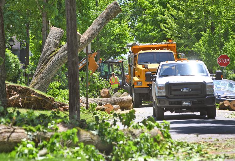
A May 23 tornado, bringing wind speeds of up to 85 mph, swept through parts of Johnstown’s West Hills, causing a more than mile-long path of damage through Stackhouse Park, Westmont and other communities.
Across the valley in Daisytown, high winds ripped the roof off of St. Gregory Roman Catholic Church.
Over the weekend, two more tornadoes were confirmed in Indiana County.
One caused damage in Burrell Township and the other – with wind speeds of 70 mph – touched down in the Homer City area.
‘The right mix’
Thunderstorms are common across Pennsylvania each spring, but they seldom spawn tornadoes.
Jurewicz said the right ingredients need to be in place within a certain area to create the massive storms that can include twisters.
That happens far more often across the Midwest – including “Tornado Alley” in Oklahoma, he added.
“The latest research suggests that there’s actually some degree of rotation above ground within every mature thunderstorm,” Jurewicz said.
“But you’ve got to have the right large-scale weather patterns in place that favor tornadoes. That doesn’t happen very often here.”
The past two weeks have been a different story.
Pennsylvania has been in the geographical center of a battle ground between warm, humid air from the south and cooler air to the north, he said.
Gusts of cool air sink as they blow, while gusts of warmer air rise – and when those forces collide near the ground, tornadoes can form.
“Usually in our region, one of the elements needed for that to happen isn’t right,” Jurewicz said. “If the jet stream moves a little bit, and that cold air sweeps in too far, a tornado doesn’t happen.”
More to come?
Across the area, residents were still picking up debris from last week’s storm.
Westmont Borough staff notified borough residents to pile up limbs and similar debris on their curbs for collection later this week, borough staff said.
As of 3 p.m., all roads were reopened to traffic.
But an expected overnight storm could cause more issues for the Wednesday commute, forecasters said.
“From what we’re seeing now, it looks like it’s going to be another active week,” he said. “There’s going to be a frontal boundary hovering over the state for the next few days, at least.”
Twister classifications
The National Weather service used the Enhanced F-scale (named for Dr. Theodore Fujita) for rating tornadoes, based on wind speed:
• Weak (EF0, EF1): Wind speeds of 65 to 110 mph.
• Strong (EF2, EF3): Wind speeds of 111 to 165 mph.
• Violent (EF4, EF5): Wind speeds of 166 to 200 mph or more.
Article Taken from:https://www.tribdem.com/news/active-time-for-twisters-western-pennsylvania-weather-patterns-create-wave/article_75657d54-8191-11e9-a40f-03ea424f5a21.html
Check out some reference links.